Sight seeing, outdoor pursuits or lazy days at the beach.

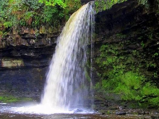
Waterfall Country
The Brecon Beacons
Located right on the south-westerly edge of the National Park this area is amongst the most beautiful and popular parts of the National Park. Here the rivers Mellte, Hepste, Pyrddin and Nedd-fechan wind their way down deep, tree-lined gorges, over a series of dramatic waterfalls, before joining to form the River Neath. This area is of international importance and it has been designated as a Special Area of Conservation (SAC) and a Site of Special Scientific Interest (SSSI).
Pontneddfechan Waterfalls
This walk takes you along a series of beautiful waterfalls from the village of Pontneddfechan in the Brecon Beacons. It's a splendid walk through lovely woodland gorges with rushing water and interesting rock formations to enjoy. The route generally takes place on well maintained, flat paths though there are couple of slightly awkward spots to negotiate.
The walk starts in the parking area in Pontneddfechan and follows footpaths north along the Afon Nedd Fechan before branching off to the left along the Afon Pyrddin to take you to Sgwd Gwladus falls. You then double back to return to the Afon Nedd Fechan and head north east to take you to Scwd Ddwli falls. Shortly after you come to Pont Melin Fach where there is a nice picnic area by the river. There's also another car park here so you could use this as an alternative start point to the walk.
There are a number of waterfalls to see -
Sgwd Gladys
Nedd Fechan
To name just two of them.
15 Miles (23 mins) away.
Great parking and a visitor centre with two real good pubs close next to the parking.
These are moderate distances with well-maintained paths.


Ystradfellte 4 Waterfalls
This is a great trail with stunning scenery and access to four waterfalls near Ystradfellte in the Brecon Beacons National Park. Starting from Gwaun Hepste car park the trail follows the Afon Mellte.
The waterfalls you visit on this route are Sgwd Uchaf Clun Gwyn, Sgwd Isaf Clun Gwyn and Sgwd yr Eira on the Afon Hepste. This trail can be steep at some points especially when walking down to see the waterfalls but overall breathtakingly beautiful. Good boots for slippery surfaces are recommended.
As mentioned is a stunning but care is needed at certain parts of the walk. Making this one a tough one (but worth it)
19.6 Miles (33 mins)
There are two parking spots and might be good to take change.
Melincourt Falls
One of the unsung waterfalls in an area of South Wales known as Waterfall Country.
I suspect the reason why this falls wasn’t as well known as the others was that it was not part of the Brecon Beacons National Park.
10.3 Miles (18 mins)
This has ample parking across the road from the start of the walk and is very easy and quick walk. Takes between 5 and 10 mins to get to the falls


Henryd Waterfall
The tallest waterfall in southern Wales with a drop of 90 feet (27 m). It lies on National Trust land, in the county of Powys.
The waterfall is reached after a steep walk down into the valley from the car park established by the National Trust, and is a popular spot to visit. A further footpath leads steeply down to the falls on the opposite side of the valley from Heol Henrhyd, the road through Coelbren village.
This fall was used as the entrance to the Batcave in the Christian Bale Batman movies.
This has great car park and the path down is step but well maintained. There are a number of wooden steps.
14.5 Miles away (30 mins)


Afan Forest Park
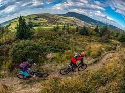
Afan Forest Park has around 130km of biking trails, ranging from easy family rides to the strictly-for-experts. Afan Forest Park is a good place to start, with the valley’s family–friendly Rookie Trail, and there’s plenty for experts too. There’s even more for advanced riders further up the valley at Glyncorrwg. Both centres are fully loaded with bike hire/café/facilities, and they’re linked by an easy family-friendly trail. Just on the other side of the valley near Tonmawr, a third site – Afan Bike Park – has several shorter, highly technical runs for advanced riders to test their skills.
Margam Park
Time for something calmer? Margam Park has acres of parkland to relax in, including ornamental gardens, a deer park and even a narrow-gauge railway. Okay, thrill seekers, you’re never far away from your next adrenalin fix – Margam Park’s Go Ape takes you into the treetops for a healthy dose of high wire adventure!


Swansea and The Gower Peninsula
The Gower
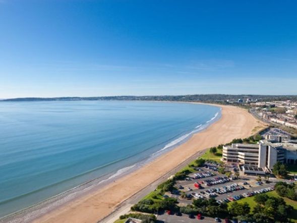
Swansea Bay (Welsh: Bae Abertawe) is a bay on the southern coast of Wales. The River Neath, River Tawe, River Afan, River Kenfig and Clyne River flow into the bay. Swansea Bay and the upper reaches of the Bristol Channel experience a large tidal range. The shipping ports in Swansea Bay are Swansea Docks, Port Talbot Docks and Briton Ferry wharfs.
Gower Peninsula is About 70 square miles (180 km2) in area, Gower is known for its coastline, popular with walkers and outdoor enthusiasts, especially surfers. Gower has many caves, including Paviland Cave and Minchin Hole Cave. The peninsula is bounded by the Loughor Estuary to the north and Swansea Bay to the east. Gower Area of Outstanding Natural Beauty covers 188 km2, including most of the peninsula west of Crofty, Three Crosses, Upper Killay, Blackpill and Bishopston.] The highest point of Gower is The Beacon at Rhossili Down at 193 metres (633 ft) overlooking Rhossili Bay Pwll Du and the Bishopton Valley form a statutory Local Nature Reserve.
The southern coast consists of a series of small, rocky or sandy bays, such as Langland and Three Cliffs, and larger beaches such as Port Eynon, Rhossili and Oxwich Bay. The north of the peninsula has fewer beaches, and is home to the cockle-beds of Penclawdd.
The northern coast is mainly salt marsh, and is used for raising Gower salt marsh lamb which was awarded protected status in 2021. The interior is mainly farmland and common land. The population mainly resides in small villages and communities with some suburban development in eastern Gower; part of the Swansea Urban Area
Swansea Bay
Swansea Bay (along with the rest of the Bristol Channel) has one of the highest tidal ranges in the world. This offers a potential for electricity generation using tidal lagoons.
A number of car parks close to Marina and a number down the stretch towards Mumbles


Bracelet Bay/Mumbles
Is a small bay on the south of the Gower Peninsula. It is the first bay one comes to after leaving Swansea Bay and rounding Mumbles Head.
Surrounded by limestone cliffs, the bay is pebbly, with some sand. To the west, the bay is separated from Limeslade Bay by Tutt Hill, the location of a coastguard look-out station.
A notable feature of the bay is the "Big Apple" kiosk, a concrete structure that was erected by the roadside during the 1930s as an advertising feature and has been a sales outlet ever since. Several similar kiosks were erected along the South Wales coast, but the one in Bracelet Bay is the only example surviving. In 2010 it was largely rebuilt after being damaged by a vehicle the previous year, and in 2019 it was designated a Grade II listed building.
The name 'Bracelet' is thought to be a corruption of 'Broad Slade'
Great little village with ample parking and restaurants etc
Rotherslade and Langland Bay
Rotherslade Bay beach is nestled around the corner from Mumbles. It's a small and sandy stretch, that's easily accessible by road.
The sea front of Langland and the adjacent Rotherslade, or 'Little Langland' as it is sometimes known, were once the location for three hotels: the Langland Bay, the Ael-y-Don, and the Osborne; and three further hotels - the Brynfield Hotel, the Langland Court, and the Wittemberg - were located in the immediate hinterland. All bar one have closed over the past forty years, and have been replaced with apartments (Langland Bay, Osborne and Ael-y-don), converted to a nursing home (Brynfield), closed and subjected to arson attacks (Langland Court and, previously, the Osborne). The Wittemberg was partially demolished and re-opened in its original Victorian core as the Little Langland Hotel.
In 1897 the French Impressionist painter Alfred Sisley made two watercolours of Langland Bay, while on honeymoon. He was staying at the Osborne Hotel, which overlooked both Langland Bay and Rotherslade Bay. Over twenty paintings resulted from his visit to Penarth and the Gower. Two of them are now in the National Museum of Wales in Cardiff.
As well as the beach huts that still exist, Langland Bay was famous for its 'community' of green canvas beach tents. These were erected annually, usually between April and early September, on the stoney storm beach in front of the promenade. A local spectacle was the early September 'spring tide watch' when rough seas would occasionally cause the loss of one or two.

Caswell Bay
Caswell Bay has a cafe, which is open all year round, and a beach shop. The Surfside Cafe suffered severe storm damage in January and February 2014, but reopened in the spring following repair and refurbishment. There are also public toilets and outdoor public showers.
Swansea City Council operate a Lifeguard service 7 days a week from early May to the beginning of September. The bay is a popular surfing location and is home to a surf school offering lessons all year round. It has a fully adaptive and inclusive surf centre, which opened in 2020 next to the public car park. It is also a renowned rock pooling location
The Bishop's Wood nature reserve sits behind the bay, a rare example of a limestone woodland. The nature reserve is open to the public for unaccompanied visits at any time. Educational tours can be arranged through the Bishop's Wood countryside centre.
Great car park but fills up in the busy months with the usual café and beach shop


3 Cliffs Bay
Three Cliff Bay is one of the Gower’s most photographed locations, and for good reason. A wide bay of golden sand backed by gently sloping dunes to the rear Three Cliff is easily recognised by the limestone headland to the east with its iconic three summits. Three Cliffs has been cited as both Britain’s best beach and Britain’s best view on separate occasion.
Despite Three Cliffs Bay’s obvious attractions it is rarely very busy and often empty in the winter. Nature is still in charge here and care should be taken if you are thinking about taking a dip here. At high tide there are often strong rip currents making it a dangerous spot for bathing. There is a seasonal lifeguard service and it is only advisable to enter the water during this period.
The bay actually consists of several smaller beaches and coves including Pobbles Bay to the east and Tor Bay to the west. Whilst separated at high tide these beaches can be reached from each other by foot at low tide over the sands.
Accessible from a couple of car parks but the main one which is an open field at Shepherds store.
Port Eynon & Horton
Port Eynon Bay is probably Gower's most popular beach, due to the fact there are many caravan and campsites situated within a mile radius of the village. It has good access, plenty of parking, shops and three quarter's of a mile of golden sand backed by sand dunes. It is popular for all types of watersports including, diving, sailing, surfing and windsurfing, with a slipway to the beach. It is a safe beach for swimming, but do not swim directly in front of the slipway as this is the boat area. You can walk across the beach to the village of Horton, located just above the dunes. Bathing is safe, but watch out for the boats, keep away from the launching area. There is a Lifeguard patrol during the summer months, you should always swim between the flags.


Oxwich Bay
Oxwich Bay is one of Gower's most popular beaches, with good access, plenty of parking, shops and two and half miles of golden sand backed by sand dunes, salt marshes and woodland.
It is a haven for all types of water sports including, diving, sailing, water-skiing and windsurfing, with a slipway to the beach. It is a safe beach for swimming, but do not swim directly in front of the slipway as this is the boat area. You can walk across the great expanse of sand towards Tor Bay and Three Cliffs Bay and on a low tide you can walk as far as Pobbles Bay.
Oxwich Bay Beach is dog friendly with dogs allowed on the beach all year.
Rhossili Beach
Rhossili Bay curves along an arc running northwards from the village. The 2.8-mile (4.5 km) wide sandy beach is backed with sand dunes. Some locals refer to the beach as Llangennith Sands. Behind the beach just north of the village is Rhossili Down with the highest point on the Gower Peninsula, the Beacon (193 metres), and a number of prehistoric remains. It is between Rhossili Down and the beach that the Warren is found. In some of the fields on "The Vile" in Rhossili, the National Trust plant every year around 400,000 sunflowers. This is an extremely popular attraction for visitors to take selfies at during late July and early August, however there have been issues with some visitors picking the flowers.
At the southern end of the Bay is worms head, consisting of two tidal islands: Outer Head 184 feet (56 m) and Inner Head 154 feet (47 m). At the north is Burry holms. These islands are accessible only at low tide.
Rhossili Bay featured in the opening ceremony of the London 2012 Olympic Games, a youth choir began a Capella performances of "Bread of Heaven" live on the beach which was broadcast at the Olympic Stadium. The bay has been used as the setting of New Earth in the sci-fi show Doctor Who and the bay including the Old Rectory was used in Torchwood: Miracle Day. In 2014, it was voted the UK's number one beach, third best in Europe, and 9th best in the world, by Trip Advisor users

More information is available with our staff
Don't hesitate to reach out to our staff if you need any information
We need your consent to load the translations
We use a third-party service to translate the website content that may collect data about your activity. Please review the details in the privacy policy and accept the service to view the translations.

